
Where Our Big Ideas Are Headed!
Monday 2/26- From what everyone already knew, our group ran into a bind due to the fact that the geographic software wasn’t compatible with any of our laptops. However, Gabriella figured out which desktops in Carrier allowed us access to the software. Mark has been able to assist us with figuring out how exactly to use the software; especially with converting files, recommendations and suggestions when using such unfamiliar software. (Unfamiliar to our group at least.

While trying to assist Gabriella with the actual design, DanDan and Ana right now (along with the help of Mark,) are here as right hands in finding the exact coordinates that we want to use. Also, they are collaborating to create a lesson plan that is going to be used in educating the kids (and their instructors) about how demographics have evolved over the centuries and how the “thumbprint” in the mountain came about. In our research on the Massanutten Mountain area, we are trying to answer the following main ideas: How it was created, will it effect the geography in the future, what’s unique about it?
As the project making progress, we made more specific plans and timeline for our project.
For our final project presentation we would like to plan and host a workshop for JMU faculty and student educators to teach them how to: incorporate 3D printing into their classroom (lesson plans, designing tools themselves, finding pre-existing tools) and how to teach their students of varying ages how to use the technology. After speaking with faculty from the education department we have been informed that many classrooms around Harrisonburg have this technology readily available. Lastly, we want to show students, faculty, and educators how this technology is beneficial to learning and may be effective in each of their classrooms.
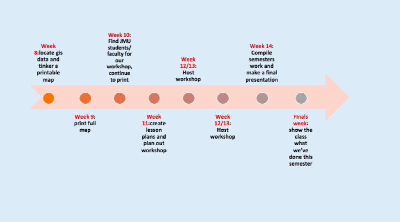
Our ideal plan for the rest of the project is……
Week 9: print full map (not sure what it will be of yet)
Week 10: Find JMU students/faculty for our workshop, continue to print
Week 11:create lesson plans and plan out workshop
Week 12/13: Host workshop!
Week 14: Compile semesters work and make a final presentation
Finals week: show the class what we’ve accomplished this semester!
This week our team has made a poll regarding potential days and times we could host our workshop. This will be sent out to several JMU faculty members and students in the education department who might be interested in attending. The poll will be sent out immediately following our spring break, so that our potential attendees have a clear idea of when they are available.
Furthermore, we had the opportunity to delve into new software and data provided by JMU. With the help of our classmate Mark, we mustered through this very uncharted territory! With Marks insight we learned how to use the universities GS data and how to analyze and alter it in ARCGIS. ARCGIS is a geographic information system for working with maps and geographic information. This software is mostly used for creating and compiling geographic data. Our hopes is to use ARCGIS to transform the relevant data we have on hand to a 3D topographic model. We have yet to print something because we are unsure if the data we have on hand is capable of being converted into a meaningful 3D model, but we are eager to keep trying.
EdutechWiki – 3D Printing of Digital Elevation Models
– StackExchange – Convert DEM to STL (3D Print Format)
– Instructables – 3D Printing Models of Landscapes (Topology, Mountain, etc.)